.© BRGM - Anne-Valérie Barras")


|
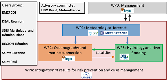
The work and the related research activities are organized around four axes: (1) meteorological forecast (2) oceanography and marine submersion (3) Hydrology and river flooding (4) Integration of results for risk prevention and crisis management.
(1) Meteorological forecast The main objective of this axis is to address some limitations of the wind, pressure and rainfall forecast products hampering a relevant prediction of hydrodynamic conditions and potential marine and river flooding. First, the uncertainties related to cyclonic forecasts will be addressed by adopting an ensemble approach to provide probabilistic information on the potential evolution of the ongoing cyclone. Two methods (parametric and dynamic) will be tested to generate the associated 2D wind and pressure fields for sea states modelling. Concerning rainfall forecast, sensitivity tests will be conducted (assimilation of radar and satellite observations, ocean-atmosphere coupling, high resolution, etc.) on the research model Arome-OI/Meso-NH (2) Oceanography and marine submersion The second axis is dedicated to the development of an oceanographic and marine inundation forecast unit. Existing hydrodynamic models implemented at Reunion Island will be adapted for a real-time use as well as improved and coupled so as to provide the best possible prediction of the total water level at the coast including the contributions of tide, storm surge, and waves. The forecasts will be available at two different scales. At the scale of the island, the models will provide information of coastal hydrodynamic conditions (total water level and waves) around the island. For several local sites, the models could provide further information on coastal flooding (extent, level, duration, currents). Finally, optimization techniques dedicated to real-time coastal flooding forecasting will be investigated with meta-modelling techniques. (3) Hydrology and river inundation Within this axis, scientific advances on cyclonic rainfall forecasts from the PRECYP project and data assimilation technics will be exploited to implement a strategy of inland floods forecast. As for the coastal flooding, different scales will be investigated. At the scale of Reunion Island, a global approach will be settled to simulate simultaneously the water flow of the main river basins. For several local sites, inland flooding models will be implemented to simulate the flood in complex environments, notably estuarine. This axis will thus enable one to evaluate and quantify the benefits of the improved rainfall forecasts models of Météo-France for inland flood predictions. (4) Integration of results for risk prevention and crisis management This axis will be involved at every stage of the project as an interface with the end-users to (i) better target the concrete needs of emergency managers during the crisis (ii) determine the most appropriate supports of communication (iii) organize dedicated crisis management exercises. The objective is to guide the developments of the three previous axes and to develop adapted tools to integrate and present their results and associated uncertainties. Reflections will also be carried out to determine how marine and river floods forecasts could be integrated in the present crisis management organization.
|
Dernière mise à jour le 22.09.2016